Adjacent to the village is the Buckinghamshire hamlet of Little Tingewick.....see Google map
Finmere lies within the county district of Cherwell and the name 'Finmere', is understood to mean "pool frequented by woodpeckers" (Source - The New Oxfordshire Village book).
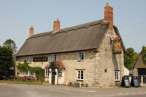
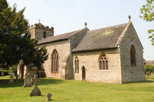
The village boasts, one Public house (The Red Lion), one 14th century church (St Michael & All Angels), one Primary school, one Cricket team and one Football team, a large playing field with a children's play area adjacent to the well appointed Village Hall.
To the south of the village lies the site of the Finmere airfield (RAF operational 1942/45). The airfield is now occasionally used by light aircraft and hang gliders, and for sheep grazing. An occasional Saturday Car boot sale also takes place on the airfield.
A section of the old Roman road (Bicester / Towcester) runs to the east of the village and forms the boundary between Oxfordshire and Buckinghamshire.
Also running close to the village boundaries are the upper reaches of the Great Ouse river.
Select here for a more comprehensive history of Finmere.
A description of, and background to Finmere, may also be found on the Finmere page at Wikipedia
Thank you for visiting.
Pictures on this page courtesy of www.oxfordshirevillages.co.uk