The Flood of 1998
Newsletter 17: April 1999
The April Deluge
After years of drought and threatened hosepipe bans, the floods of April 1998 caught everyone by surprise. This included the Environment Agency, which has responsibility for monitoring water levels. Here, we look back at Finmere’s wettest moment.
The weather in April 1998 was very unsettled throughout the UK. Over the course of the month, between 1.6 and 3.2 times the monthly average rainfall fell. The most severe problems were early in the month. In the first week 20 to 30 mm of rain fell over the Midlands, saturating the soil.
On Tuesday, 7 April, the weather deteriorated. An area of low pressure formed near Iceland. The next day, this depression moved south across the UK precipitating 10mm of rainfall. It had two frontal systems to its north and south. On Maundy Thursday, 9 April, the fronts began to converge. Thunderstorms broke out ahead of the southern front as it moved north. But instead of moving up the country, the storms were squeezed in by the northern front moving south. They remained almost stationary and poured prolonged and heavy rain across central England.
Torrential rain fell in a band between 50 km and 100 km wide and about 300 km long. It stretched from the Black Mountains in south Wales to north Cambridgeshire. The worst downpours were near Pershore, where 90 mm fell over 14 hours, and near Peterborough, where 97 mm fell in 22 hours.
Neither the saturated soil nor the swollen rivers could cope with this deluge. The result was widespread flooding across central England as rivers burst their banks and drains failed to cope.
Buckingham
Buckingham is 30 km downstream of the source of the River Great Ouse. It has a history of flooding. The river burst its banks and the town severely flooded in 1939 and 1947. In 1979, 45 houses and 8 industrial properties were inundated.
At 17.05 hours on 9 April 1998, rising water at Brackley triggered an amber warning. This indicated a risk of flooding to isolated properties, roads and large areas of farmland. Twelve minutes later, emergency services, local authorities and the media were informed. These warnings were too late. Flooding had already begun in Buckingham. By the end of the afternoon, 25 houses and five non-residential buildings were under water.
The Environment Agency estimates that such a severe flood will only occur once in one hundred and twenty-five years. It is currently reviewing flood warning and protection arrangements for the town.
Finmere
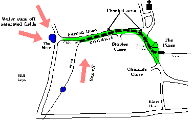
The flooding in Finmere was not from the river, which is one mile to the north of the village. It was caused by run-off from saturated fields and a lack of capacity in a culvert under the village.
Water drains through Finmere from west to east. It once flowed in an open stream along the Fulwell Road. By the early nineteenth century, this was contaminated with pollution from cesspools. Dr Clarke, who lived in Finmere House, was concerned about the impact on villagers’ health. He had the stream enclosed in a conduit. This runs under the road from Chippings on Fulwell Road to The Pines. It is just 48cm high and 35cm wide.
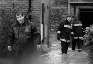
In the morning of 9 April, standing water began to collect outside Stone House on Valley Road. The conduit had reached capacity, due to the volume of rain and silt partly obstructing its eastern end. The road was soon blocked by water and several houses were threatened. The Fire and Rescue Service arrived after noon and a sandbagging party of villagers and fire crew was organised.
It continued to rain torrentially. Water backed up the culvert to its entrance at Chippings. Sheets of water flashed across the fields down to the Mere and in front of the Barracks into the stream. This water could no longer flow through the culvert and poured onto Fulwell Road. There it met water backing up from Stone House.
The Flood
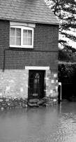
Sandbagging in The Pines
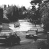
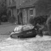
By one o’clock in the afternoon, the flood extended from Mere Cottage on Fulwell Road to the entrance of Chinnals Close. It was at its deepest, 60cm, opposite Stone House. As the water rose, the sandbag party struggled to protect houses.
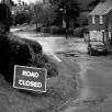
 At this point, roads in the entire region were affected. The A421 was blocked at Tingewick and under the railway bridge at the Shelswell Inn. The A422 Buckingham to Brackley road was barely passable at several points. The M40 was closed north of Ardley. Drivers were anxious to return home or reach their Easter holiday destinations. Traffic spilled off the major roads in an attempt to find a route past the floods. Motorists found that local roads were also blocked.
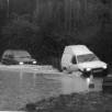
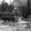
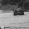
Many drivers attempted to pass through Finmere and some succeeded. Others flooded their engines and were marooned. They had to push.
|
|
|
|
|
|
By early evening, the flood had subsided. But the damage had been done. Four houses had been flooded and several vehicles damaged.
Peak Flooding
The pictures below were taken about one o’clock at the peak of the flooding and in torrential rain.
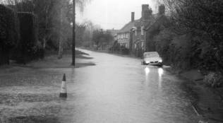
Fulwell Road looking from the Cross Tree
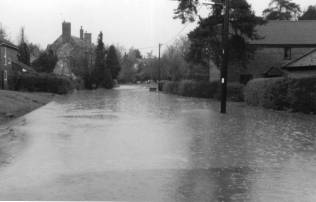
Valley Road looking towards the Cross Tree
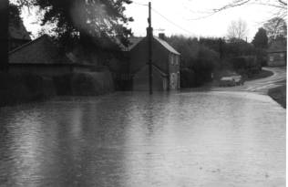
Valley Road looking towards Finmere House
Earlier Calamities
There have been smaller floods by the Cross Tree and on Fulwell Road before. We have not heard of a flood as serious as that of 1998. Due to lack of space, we will cover the storm of 1661 in a later newsletter.
Acknowledgements
Our thanks to the Fire Rescue Service and to the sandbagging party for helping during the floods. Photographs by Andy Boddington and Ian Macpherson. Weather and flood warning data from the Environment Agency.