Water, Wells and Pumps
Newsletter 8. January 1998.
Finmere and Water
Finmere, with many springs and wells, has a long association with water. This includes the name Finmere itself. The authoritative English Place Names Society suggests that Finmere might mean ‘pool frequented by woodpeckers’ [mere-fina]. Woodpeckers still nest in the village but there is uncertainty whether the Fin element derives from the Old English word fina or fyne. The latter means ‘mould’; so perhaps our village name means ‘mouldy pond’, or just very damp!
There is an alternative interpretation. Celtic (pre-Roman) names abound in the English landscape. Chetwode in Buckinghamshire, for example, is a combined Old English-Celtic word meaning wood and Brill is a Celtic name for hill. The River Ouse flows across the north end of the Parish; this is a Celtic name (Uisce) that simply means water. Tim Killeen suggests that the Fin element of Finmere might also be Celtic: it would mean ‘fair, clear or bright.’
Whatever, the meaning of our village name, it is clear that Finmere has long been associated with water. In this issue we explore the village’s early water resources.
Water Supplies
Initially, villagers would have drawn supplies from surface springs and wells. Waste was dumped in convenient, if unhealthy, cesspools.
The first attempt to improve hygiene was made by Dr James Clark. James was an Edinburgh trained doctor who lived in Finmere House with his brother, Charles from 1830. J.C. Blomfield described Clark’s achievements in his 1887 History of Finmere:
[James] was instrumental in effecting some much needed improvements in the sanitary condition of the village, by the removal of cesspools and other nuisances injurious to health from the doors of the cottages, and by the covering over of the brook where it ran through the village. He was also a very clever mechanic, as was evident from the improvements he made in the Church clock in 1859, and the windmill for pumping water, and other ingenious contrivances, which are on the premises of his late residence.
Victorian Dowser
As the village grew, the need for water increased. In 1887, Rector Seymour Ashwell employed a West Country dowser to prospect for locations for wells:
Oct 19th. John Mullins came from Colerne in Wiltshire and marked by means of a ‘divining rod’ different places on the Glebe where Wells of Water could be dug. The rod in question being a small hazel twig of this shape ![]() . The different places are marked on the Ordnance Survey Map by a blue spot. A well at the East end of this Parish was dug at one of the places indicated and arched over with a date stone on top. At the expense of the Rector.
. The different places are marked on the Ordnance Survey Map by a blue spot. A well at the East end of this Parish was dug at one of the places indicated and arched over with a date stone on top. At the expense of the Rector.
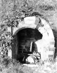
Unfortunately, this map does not survive. The well at the east end of the parish was on Mere Road (marked [A] on the map overleaf). The picture (left) was taken shortly before it was destroyed by builders in the early 1990s.
The Village Pumps
Two pumps survive in the village. One is on Mere Lane in Little Tingewick and is now in need of care and attention [B]. The second is in Valley Road and has been carefully restored by Tim Killeen [C].
Both pumps were manufactured by E&H Roberts at the Britannia Ironworks in Deanshanger. Edwin and Henry Roberts ran a family business founded by Edwin’s grandfather, Richard, in 1821. Despite being gutted by fire in 1912, the business survived only to go bankrupt in 1927.
The pump on Valley Road is the older of the two. The pump on Mere Lane was manufactured after the Roberts had established a limited company in 1890. The Roberts also made drain covers; examples can still be seen in Valley Road and inside the Church gate.
Finmere’s’ Wells and Pumps.
The map below is based on the first detailed Ordnance Survey map of Finmere printed in 1881. Thanks to the work of Tim Killeen, we have been able to add the location of wells and pumps. If you know of other wells in the village, please let us know.